
Historic Flooding in Spain: An Urgent Call for Action
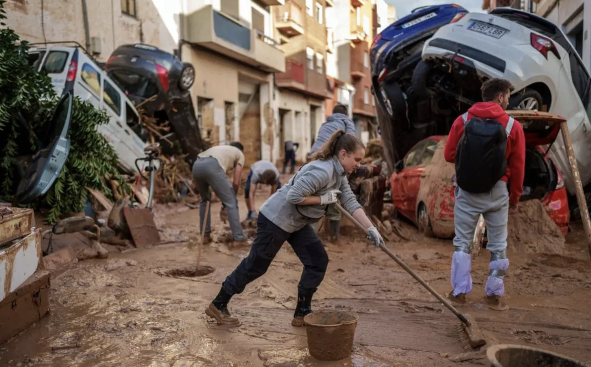
Community members join efforts to clear mud from the streets in flood-affected areas of
Paiporta, a town in the region of Valencia. (AP photo)
Introduction
The historic flooding last November in Valencia, Spain, was unspeakably devastating, causing significant loss of life, widespread property damage, and severe economic disruption. The region experienced torrential rainfall that led to flash floods, inundating streets, homes, and businesses. The impact of this extreme weather event has been far-reaching, affecting communities and industries alike.
The Spanish government has allocated substantial resources for emergency response and recovery efforts in the wake of the devastating floods in Valencia. While the exact costs are still being assessed, the financial burden is already heavy. The government will need to fund emergency services, infrastructure repairs, and social support programs for affected communities.
As climate change intensifies, the frequency and severity of extreme weather events are expected to increase further, making it imperative to develop innovative solutions to build resilience and protect communities. Moreover, the risks raised by climate change extend well beyond Spain or Europe, as demonstrated by recent flood events in Brazil’s Rio Grande do Sul and across the Philippines, Laos, Vietnam, and Myanmar. Government agencies and business communities are among those seeking new strategies and approaches to predicting such megastorms and mitigating the losses and damage they leave in their wake.
The Changing Landscape of Weather Events
The Valencia event is said to be Spain’s deadliest natural disaster in decades. By one estimate, the storm killed at least 219 people, with another 93 people missing. According to estimates released by Spain’s Consortium for Insurance Compensation, which pays insurance claims for extreme weather events like these, payouts will total at least 3.5 billion euros. The transport ministry has repaired more than 232 kilometers[1] of road and railroad tracks, although the high-speed train service between Madrid and Valencia remained inoperable as of early November.
By this time, the Consortium had received 116,000 insurance claims for flood damages, of which 21,000 were home claims, 12,000 were for business properties, and 44,000 were for vehicles.
Spain’s central government has approved a 10.6 billion euro relief package for families, businesses and institutions, and the Valencia regional government seeks an additional 31 billion euros in additional aid.
Catastrophic weather events like these have been extremely rare in the past. The Valencia flooding was caused by a known seasonal weather pattern known by the Spanish acronym DANA, which stands for Depresión Aislada en Niveles Altos (isolated depression at high altitudes). DANA storms take shape the same way that Atlantic hurricanes or China Sea typhoons form. A half-century ago, a DANA occurred every three or four years, typically in November. Today they can happen all year round.
The changing climate has altered weather patterns worldwide, leading to an increase in the frequency and intensity of extreme weather events. This Fall alone, similar storms affected regions in France, Italy, Austria, and the Czech Republic. Some regions of Poland, Germany, and the Czech Republic suffered three months of rain in just five days this September.
The link between climate change and its influence on weather patterns is clear. Historical analyses conducted by WWA indicate that extraordinarily heavy 1-day rainfall events like this one are about 12% more intense and about twice as likely in today’s climate than would have been in the cooler preindustrial climate without human-caused warming. Indeed, the collaborative cites a 19th-century thermodynamic equation known as the Clausius-Clapeyron relation, which holds that that a warmer atmosphere can hold more moisture, resulting in a 7% increase in heavy rainfall with each 1°C of warming.
To say that the world is in dire need for better mitigation strategies seems a gross understatement.
Can GreenAnt’s Desidera Platform Help Build Resilience?
Among its many capabilities, GreenAnt’s risk mitigation tool, Desidera, is able to forecast flood risk. To access this feature, a Desidera user simply needs to trace a plot of land on the platform’s interactive map to be analyzed. Desidera then uses a sophisticated set of AI algorithms to process satellite data and assess environmental risk. These algorithms, which account for factors like soil drainage capacity, biomass, and hydrologic landscape, determine the quantity of rainfall required in an area that would trigger flooding.
These capabilities can be used by local and national governments, insurance companies, and individuals alike to anticipate disasters like the one we saw in Valencia before they strike and better prepare communities ahead of time.
Benefits for Government Regulatory and Relief Organizations
Armed with Desidera’s insights, public agencies can leverage local weather and rainfall forecasts to predict and plan for flooding. These agencies can also use flood risk profiles to develop data-based disaster relief plans, retool their environmental and infrastructure policies, and alert and/or evacuate communities before a potentially devastating flood occurs.
In addition to flood risk forecasting, Desidera can process satellite data over time to track the progression of floods in near-real time. By analyzing water level changes and its spread over land, these insights can serve as valuable information to emergency responders and decision-makers to aid in flood response and mitigation efforts. This information can help emergency responders prioritize their efforts and allocate resources to the areas with the greatest need, such as those with significant infrastructure damage or widespread flooding.
Additionally, Desidera can provide valuable data for post-disaster recovery planning. By assessing the extent of damage to infrastructure and agricultural land, authorities can prioritize reconstruction efforts and allocate resources effectively.
In this age of climate volatility, government agencies and nongovernmental relief organizations alike stand to transform their operations and achieve new levels of success by leveraging tools like Desidera. A better understanding of the conditions that cause these events — and in the case of flood risk, knowing the amount of rainfall needed to spur a flood before that flood occurs — can empower us to reduce losses, protect assets, and, most importantly, save lives.
Using Desidera, community members can take disaster prep into their own hands by forecasting their own personal flood-related vulnerabilities, anticipating disasters, and creating contingency plans for their families and loved ones.
Benefits for Insurers
Insurance companies can utilize Desidera to evaluate the risk associated with different properties and develop more accurate insurance pricing models. Following a natural disaster, Desidera can also analyze satellite imagery to assess the extent of damage to crops, infrastructure, and property. This information can be used by insurance companies to expedite claim processing and provide timely compensation to affected individuals and businesses.
Beyond Flood Risk Analysis
Through its ability to analyze changes in soil moisture over time, Desidera can identify areas at risk of drought and forest fire and provide early warnings to farmers, allowing them to adjust irrigation practices and conserve water. Desidera also monitors crop health, height, and growth stage in near-real time and forecasts future crop yields, optimizing the way in which farmers tend to their land. Finally, Desidera can monitor deforestation and forest degradation and can estimate carbon sequestration in biomass on the ground. These insights can support public sector actors develop and enforce environmental policies.
By providing data-driven insights into soil moisture levels and plant water stress, Desidera can enable farmers to optimize irrigation schedules. Armed with this information, farmers can reduce water waste and improve water use efficiency by precisely targeting irrigation to areas that need it most.
Conclusion
In recent years, the world has witnessed a growing frequency and intensity of extreme weather events, including floods, droughts, and heatwaves. Climate change has exacerbated these trends, making it imperative to develop innovative solutions to mitigate the impacts of these events.
GreenAnt's Desidera platform offers a powerful tool to build resilience against flooding and other climate-driven disasters. By providing timely and accurate insights into flood risk, agricultural conditions, and natural hazards, Desidera empowers stakeholders to make informed decisions, mitigate risks, and adapt to the changing climate.
To learn more about how GreenAnt's Desidera platform can help you manage risk and prepare for future extreme weather events, please visit our website or contact our team today. Let's work together to build a more resilient future.